Showing posts with label bike trail. Show all posts

Saturday, May 11, 2013

Amelia Island Trail (AIT) officially opened today in Fernandina Beach, Nassau County, FLA

The Amelia Island Trail (AIT) officially opened today in a ribbon-cutting ceremony at Peter's Point Park in Fernandina Beach, Nassau County, FLA.  Phil Scanlan, head of the Amelia Island Trail team, hosted the 45-minute ceremony attended by federal, state and local officials and by area community leaders and volunteers who helped make the 6-mile long paved off road trail a reality. Mike Pikula, President of the Friends of the Amelia Island Trail and key member of the AIT team, also spoke. The grand opening of the AIT was well attended by several hundred cyclists, joggers, runners and walkers of all ages.  The event was capped off with Nassau County Commissioner and North Florida Transportation Planning Organization Chairperson Danny Leeper given the honors of cutting the ribbon. The AIT is also part of the larger East Coast Greenway, a multi-state, 3,000 mile trail that when fully completed will stretch from Maine to Key West. Construction will soon begin on the Big Talbot Island trail that will connect the AIT with the newly completed Little Talbot Island trail. For more info on the AIT, the Friends of the Amelia Island Trail, or the East Coast Greenway, check out the links below.
http://ameliaislandtrail.org/index.html
http://www.greenway.org/index.shtml
Nassau County Commissioner and North Florida TPO chairperson Danny Leeper cuts the ribbon at the official opening of the AIT as those who helped make the decade-long dream 
a reality stand beside him.

 Phil Scanlan, head of the AIT team,  hosts the opening ceremony held today at Peter's Point park in Fernandina Beach.

 Mike Pikula, President of the Friends of the Amelia Island Trail and key member of the AIT team, speaks to the crowd of several hundred cyclists, jogging and walking enthusiasts.

 The crowd, led by the cyclists, leave Peter's Point Park and head onto the AIT. Many of the biker riders were from the North Florida Bike Club.  Joggers and runners soon followed behind them onto the trail.  The AIT team are planning to erect a kiosk nearby to mark the northern entrance to this section.

The AIT was built on the state owned right of way of SR A1A by the Florida DOT with funds from the North Florida TPO. It runs from Peter's Point Park to Amelia Island State Park, a total of 6 miles.  It will be connected to the south by the Big and Little Talbot Island Trails. The AIT will also extend north through Fernandina Beach, connecting neaby schools, parks, and community centers along the way. A passenger ferry was to connect the AIT to Georgia and the northern part of the East Coast Greenway, but unfortunately the privately owned ferry is no longer in service.
 

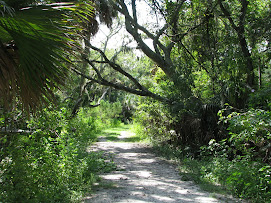
Cyclists enjoy the shade of the tree-lines trail.  Although it parallels SR A1A for its entire length, the AIT weaves in and out of the canopy-lined road. Many parts of the trail are barely visible from SR A1A, especially the southern half, giving the trail a rural flavor.
 
 
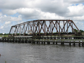
A sign post shared by the AIT and East Coast Greenway logos marks the AIT's southern entrance at Amelia Island State Park.  Construction of the Big Talbot Island link will begin shortly and will allow riders to continue south into Duval County and the Talbot Islands State Park via the Crady Bridge spans the Nassau Sound.

Saturday, October 27, 2012

Work on Amelia Island Trail progressing

 The AIT will parallel the Northbound lanes of SR A1A from the Grady Bridge to Fletcher Ave.
 The bike trail through Big and Little Talbot Island State Parks just recently opened.
The New Grady Bridge (left) mirrors the old bridge over the Nassau Sound between Duval and Nassau Counties. One will provide the link between the AIT and the Talbot Island trails, vital parts of the East Coast Greenway.
 
Work on the Amelia Island Trail (AIT) is progressing from the Grady Bridge at the southernmost point of Amelia Island northward to the Fletcher Avenue intersection. When finished in 2013, the off road bike trail will look much like the Talbot Island bike trail in Northeast Duval County that will south from the Grady Bridge through Little and Big Talbot Island State Parks to Ft. George and the Mayport Ferry.  Together the two will form an important link in the East Coast Greenway, a national bike trail that when completed will link South Florida with New England. Funds for the AIT came from grants from the Florida Department of Transportation and the North Florida Transportation Planning Organization.

Friday, April 15, 2011

Riding the Trails in Cary State Forest: The Good, The Bad, and the Beautiful


The hard surface of Pavilion Drive shown above was ideal to ride on, as was the grass covered Powerline Road. Dirt roads like the one shown below were difficult to ride on as the soft sand cause my bike to often fishtail. Since today was a great day to ride, I threw my bicycle into the back of my pick up and drive to Cary State Forest (CSF) which straddles the Nassau-Duval Line just north of Bryceville. CSF consists of several tracts of timberland that together totals 13,000 acres. It is home to countless wildlife, vegetation and of course trees which is what the pioneers to Nassau County came here for. Recreation wise, CSF is know for hiking, nature walking, camping and horse back riding. They have a nice outdoor pavilion that holds about 50 people and an observation tower to view the wildlife although there is a bike symbol on the main kiosk, some of the roads are not bike friendly. CSF has numerous roads that were once logging paths can be divided into three types: limestone paved, grass and dirt. Mike trek began on Pavilion Road which leads from the main entrance on US 301 to the Fire equipment shed, a total of about a mile. It is the only hard limestone? surface I encountered at CSF. After it ended, little used dirt roads (Fox Squirrel Road and Moccasin Slough) and that had the grassy crest in the middle were the norm for a while. My bike was no match for the soft sand that made up the ruts and I had to walk my bike on numerous locations. However, I did come across grassy roads such as Power Line and Deer Track Roads that made bike riding easier. Overall, today was a good learning experience. I had a chance to enjoy the natural beauty of Cary State Forest and experience its various types of roads. One day we may have a hard surfaced multi use trail that would connect US 301 with Ford Road through CSF.

Sunday, February 27, 2011

Rail Bed and Trestle from Callahan to Mills Creek perfect for trail


The wide rail bed behind the historic Callahan Depot


The Mills Creek Trestle and rail bed beyond


Mills Creek Trestle and old wooden pilings underneath

The abandoned CSX rail bed that runs from downtown Callahan northeast to Petree Road would make a perfect nature and bike trail. The 1.4 mile long path was once part of the historic Florida Railroad grade that was the Sunshine State's first cross peninsular track that connected Fernandina on the Atlantic to Cedar Key on the Gulf, a distance of 155 miles. Prolific railroad contractor Daniel Callahan and his crew built this now unused section in 1856. The first 1600 feet of bed between the CSX junction to US 1 is extra wide because it once held two parallel railroads, the above mentioned Florida Railroad and their rival, the Savannah, Florida and Western Railroad, built by railroad baron Henry Plant in 1881. It is void of trees and is mowed during the summer months. Old cross ties are starting to peak through the worn spots that become mud holes when it rains. This wide section (100-120 feet in width) is vacant except for the parcel containing the 1881 SFW depot owned and maintain by the West Nassau Historical Society. The non profit group hosts the Railroad Days Festival in late March to bring awareness of the important role railroads played in the development of Nassau County. Beyond US 1, the bed narrows into the typical single track grade (about 50 feet wide) as it parallels Martin Luther King Ave. The narrow width makes it unsuitable for any type of permanent structures but is ideal for a bike and nature trail. It is currently unmowed and there are small deciduous trees growing upon the bed that makes it noticeable in Aeriel view. The grade is solid, level, measures about 1 to 2 feet above the terrain and is basically intact except for a couple of cuts made for driveways and roads. However, once the bed passes Annie Laura Street (3600 feet from the CSX junction), it starts to rise as it cuts through the low wooded area around Mills Creek. MLK Avenue ends and the rail bed makes its solo trek though the low laying woods, rising from 2 feet to about 8 feet in height. It is now void of trees and the grass is kept low by a thin layer of ballast and fallen leaves. At 4600 feet from the CSX junction, the bed gives way to a 250 feet long concrete trestle that spans Mills Creek where it forms at the confluence of Alligator and Williams Creek. The bridge was built in the early 1980s over the remains of a wooden trestle whose wood pilings were sawed off at ground level under the new span. The new sturdier span wasn't used for very long as CSX abandoned the line to Gross and Savannah in 1985. Mills Creek flows from this point under the trestle eastward into Four Creeks State Preserve nearly 2 miles away. The creek is still navigate and would make for a nice kayak/canoe trip to Four Creeks. The rail bed continues Northeast from the Mills Creek Trestle for about 1500 feet until it reaches Petree Road where the line forks into two directions. To the right (east) continues the 1856 Florida Railroad bed toward Yulee. Abandoned in the mid 1950s, most of this bed has been lost to time, either leveled, sold to private owners or paved over as part of the SR 200/ A1A widening project. To the left branches the Gross Line rail bed which makes a bee line through privately own timber lands and a wildlife management area to Gross, a long vanished whistle stop near I 95 and US 17 just south of the St. Marys River. This line built by the Seaboard Air Line Railroad in 1923 was used to bypass the busy Jacksonville terminal. It was part of the 1985 rail abandonment by CSX. Today the bed and trestle would make a nice nature and bike trail connecting the historic Callahan Depot with a kayak and canoe portage via a natural wooded forest.